
Climate Maps
Maps of temperature and
precipitation patterns across the US and the globe for
historic and future climate scenarios.
For more information on future climate emission scenarios, follow this link to information and descriptions of the scenarios from the World Meteorological Organization.
For more information on future climate emission scenarios, follow this link to information and descriptions of the scenarios from the World Meteorological Organization.
Global Maps*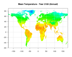
Global Temperature MapsGlobal Precipitation Maps
**Printable Global Maps
PDF of global temperature and precipitation maps. Two maps per page - current and future high emission scenario. Can be printed on 8.5x11 or 11x17 paper.Printable Global Maps (Download pdf)
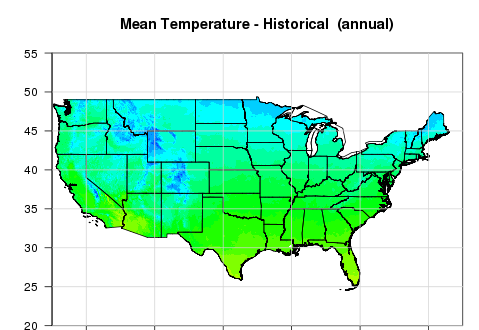
US Maps**
US Temperature MapsUS Precipitation Maps
Northeast Maps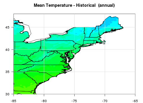
These maps are simply a zoomed
in version of the US maps.Northeast Temperature Maps
Northeast Precipitation Maps
Note: If you would like to use
these maps for a classroom presentation or project, you can
just click and drag the specific map of interest from the
screen onto your desktop.
*50 km resolution maps of historical climate are from the Climate Research Unit Time Series version 2.10 and 50 km resolution maps of future climate are from: The University of Santa Clara Statistically Downscaled WCRP CMIP3 Climate Projections. These maps are generated from an ensemble of 16 different climate models (including NASA's GISS ER model), and show output from low, medium, and high emission scenarios. Data was downloaded from the Climate Wizard website.
**4 km resolution maps of historical mean temperature and precipitation are from: “PRISM Climate Group, Oregon State University, created 4 Feb 2004.” 12 km resolution maps of future climate are also from: The University of Santa Clara Statistically Downscaled WCRP CMIP3 Climate Projections. Data was downloaded from the Climate Wizard website.