Data Tools
Confused about what a term means? Visit the Glossary page.
| Climate
Maps Maps of temperature and precipitation patterns across the US and the globe for historic and future climate scenarios 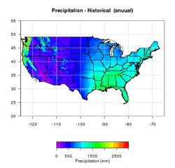 |
Animations Animations over time of historical and future climate, biomass accumulation, and vegetation indices 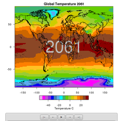 |
| Single Site Climate Data This interactive tool will generate a graph of historical/future climate for a specific latitude and longitude, as well as downloadable text data for further analysis. 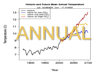 |
Carbon
Mapper An interactive mapserver that provides access to data that can be queried for any location. Data sets include: Biomes, Land cover, Albedo, NDVI, NPP, as well as GLOBE Carbon Cycle Carbon/Biomass Plot data.  |
| Picture Post Environmental monitoring by citizens and students through digital images. Student Climate Data offers feature enhancement such as animations over time, activities, and connections with NASA satellite image products.  |
Tree Atlas Interactive maps of current and potential future tree species habitats in the Northeastern US created by the US forest service. Video tutorial available here. 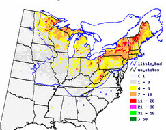 |
| Biome
Maps Maps and interactive tools relating to the biomes of the globe 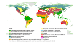 |
Related Data Resources Links to sites with friendly interfaces for obtaining earth science and climate change data.  |