
Single Site Climate Data
This
interactive tool will generate a graph of historical
and future climate for a specific location, as well as
downloadable data for further analysis.
For more information on future climate emission scenarios, follow this link to information and descriptions of the scenarios from the World Meteorological Organization.
For more information on future climate emission scenarios, follow this link to information and descriptions of the scenarios from the World Meteorological Organization.
Climate TimelineThis interface provides access to 130 year historical plus 100 year future prediction data*. Data includes temperature, precipitation, snow, surface runoff, and solar radiation under low, medium, and high CO2 emission scenarios. If you are using this with the GLOBE Carbon Cycle Biomass Accumulation Model, choose the Annual Time-line! For a more in-depth analysis, see the Monthly Climate Time-line. Download data at a monthly time-step to investigate climate changes at a finer scale, and explore differences between seasons. |
Explore and Download Data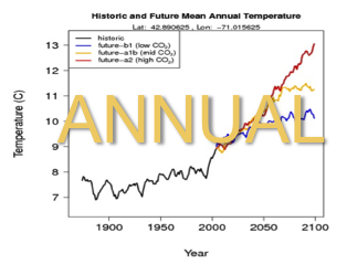 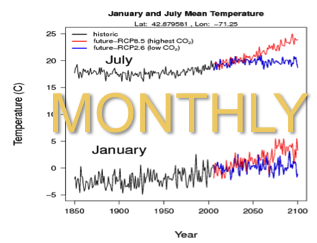 |
Climate Change ComparisonsAn interactive graph (a Google Motion Chart) of temperature vs. precipitation over 130 years of historical data and 100 years of future predictions*. Future climate projects are from a high CO2 emission scenario. With this product, you can compare the changes in climate at two different locations by inputting two different latitude/longitude pairs. Also provides biome information and a downloadable data file for further analysis. Download pdf description of the Google Motion Chart features Link to instructions for creating your own Google Motion Chart **Note: This tool needs java to run, and therefore will not run on an iPad** |
Explore and Download Data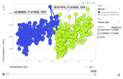 |
Seasonal AlbedoFor any latitude/longitude pair, the site will generate a graph of monthly albedo, as well as a table of land cover type and albedo values for each month.** |
Explore
and Download Data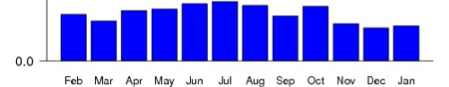 |
**Data from the National Center for Atmospheric Research (NCAR)'s Community Climate System Model, version 3.
** Albedo and land cover data
captured by the Moderate Resolution Imaging
Spectroradiometer (MODIS) instrument.